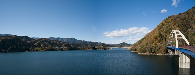
今日は北里大学病院の眼科に行こうと思っていたのだが朝出遅れてしまい、さて天気の方は予報が言うほどの強風ではないので、晴天の中、宮ヶ瀬湖を目指して走ることにした。一度ここを通って奥多摩方面に行ってみたいと思っていたところだ。
10時に自宅を出発、七里ガ浜からはくっきりと富士が見える。茅ヶ崎駅西側は自転車を降りることなく線路の下をくぐり抜けできるようになっていた。この先は寒川から伊勢原に向かうほぼ道なりのルート、所々で富士山のクローズアップも楽しめる。
I thought of going to Kitazato University Hospital to have my eyes examined today, but woke up too late in the morning. The weather looked reasonably good and the wind was not so strong as the forecast had predicted, so I decided to run my bike to Lake Miyagase as an alternative plan.
I left home at 10:00 and Mt. Fuji was very clear at Shichirigahama beach of Kamakura. At Chigasaki, there was an underground pass through the railway in the west side of the train station, and I basically needed to follow the road to north-west heading Samukawa and Isehara.
 |
| 七里ガ浜 Shichirigahama, Kamakura |
丹沢の麓、七沢温泉を経て清川村に入ると道路も里山を走る感じになる。運動公園近くで綺麗な紅葉があったので、近くの7/11に入って小休止する。
A short break at Seven-Eleven in Kiyokawa Village as I saw some beautiful trees in autumn colors.
 |
| 清川村 Kiyokawa Village |
村役場を過ぎてしばらくすると登坂が始まるが、距離にして3km弱なので手ごわい坂とは言えないが、それでも長く感じるので、湖が見えると爽快感が一気に高まる。
Passing the center of the village, soon came the steeper slope of about 3km which was not so tough in distance.
Passing the center of the village, soon came the steeper slope of about 3km which was not so tough in distance.
今回はBH Cristalの最終的な走行チェックとルートガイドを試す目的だが、105ディレーラーはほぼ完璧といって良い状態だった。GPS地図の方はナビについてこれまであれこれ試行錯誤をしてきたが、ルートラボにKMLファイルをアップしてそれをiPhoneで読み出す方法が良さそうなので、それを使ってみた。ルートのトレーサーとしてはリフレッシュが少し遅いことと、常にウェブサイトを読み込んでいるのでバッテリーの方が3時間もつかどうかというのが、実用的に厳しい面ではあるものの、ガイドとしては十分に役に立ってくれた。僕は外付けのバッテリーを持って行ったので、宮ヶ瀬湖から先はこれを接続してルートラボの表示を続けたが、そのためにANT+用のWahooが使えないことになった。
I had two specific purposes in this ride: checking if BH Cristal bike is well tuned for one thing and testing how Route Lab (a route map guide application) functions for the other. We can create our own routes in their web site, and open the KML file on a web browser as we run. I tried it with my iPhone. I thought the refresh response is a bit slow and keeping the browser and GSP functioning on the display is not so friendly to the battery. It could run as long as 3 hours. I had an external battery as a backup. But hooking it up will occupy the socket for Wahoo ANT+ device.
I had two specific purposes in this ride: checking if BH Cristal bike is well tuned for one thing and testing how Route Lab (a route map guide application) functions for the other. We can create our own routes in their web site, and open the KML file on a web browser as we run. I tried it with my iPhone. I thought the refresh response is a bit slow and keeping the browser and GSP functioning on the display is not so friendly to the battery. It could run as long as 3 hours. I had an external battery as a backup. But hooking it up will occupy the socket for Wahoo ANT+ device.
宮ヶ瀬への道中、ライダーに会うことはなかったが、湖の北側では3組くらいとすれ違ったので、三多摩方面からはポピュラーなのかも知れない。宮ヶ瀬湖を離れて相模川に向かうダウンヒルは長くて気持ち良かった。でも風は少し強かった。今日のexit routeは何と今朝来られなかった北里大学病院の前を通って相模大野に落ち着いた。走行時間は4時間ちょっと、距離は76km。
I saw no bike riders on my way to the lake, but came across with three small rider groups in the north of the lake and I thought that Miyagase might be more popular in Santama area. The downhill from the lake was long and comfortable but windy, too. I headed for Sagami-Ohno station and incidentally passed the front road of Kitazato University that I thought of coming originally. Total 76km in a little over 4 hours.
I saw no bike riders on my way to the lake, but came across with three small rider groups in the north of the lake and I thought that Miyagase might be more popular in Santama area. The downhill from the lake was long and comfortable but windy, too. I headed for Sagami-Ohno station and incidentally passed the front road of Kitazato University that I thought of coming originally. Total 76km in a little over 4 hours.


